Get Schooled: What it Takes to Become an Architect


Get Schooled is a program that encourages education and works to make positive changes in the education system. Part of that program is to find different career professionals and talk to them about how they ended up in their field and what schooling it takes to get there.


For the Get a Career feature of "What it Takes to Become an Architect," our very own Alan Hart was interviewed about his path towards becoming an architect. He talks about hurdles in his educational path, what inspires him, and about the Olympic Village as part of Southeast False Creek in Vancouver.

To read the complete interview on Get Schooled, click here.

A Look at the Transportation Association of Canada Conference

by guest blogger John Collings, Collings Johnston Inc.
The annual conference of the Transportation Association of Canada (TAC) was held in Vancouver this year and was well attended by over a thousand transportation officials, planners and engineers from across Canada. TAC is an association which provides “a neutral forum for gathering or exchanging ideas, information and knowledge on technical guidelines and best practices.” source

The newly opened spectacle of the Golden Ears Crossing was evident at the conference. The project’s urban planning and aesthetics were highlighted by Graham McGarva’s and John Collings’s poster presentation. Collings Johnston Inc. and VIA Architecture were retained by TransLink to develop, specify, and implement the urban design process for the new 14 km highway and major crossing of the Fraser River linking the municipalities of Langley and Surrey with Maple Ridge and Pitt Meadows. The design and construction was undertaken by the Golden Crossing Group between 2006 and 2009 as part of a Public Private Partnership. The project had three main urban design goals:
  • to design and build a new arterial corridor and river crossing in support of its surrounding context 
  • provide a moderate speed arterial for use by all road users: cars, trucks, buses, bicycles and pedestrians
  • implement an integrated urban design theme whose aesthetics would enrich users experience along Golden Ears Way

The presentation highlighted the process of designing a Major New River Crossing within the context of its surroundings and took the form of questions and comments as the audience passed the posters. That is to say that the audience came to the presenter instead of the presenter talking to an audience. There were about 100 conference attendees that visited the Golden Ears Crossing presentation and showed genuine interest through their inquisitive questions and informative comments with regards to the design approach. Many of these people were from the senior ranks of government and municipalities.

John Collings also gave a presentation on Context Sensitive Solutions to the Urban/Freeway Interfaces of the Golden Ears Crossing. The 15 km arterial was specified and designed as a limited speed facility in keeping with the urban features through which it passes. The iconic and landscaping features of the route provide much of the context and items such as Curvilinear bridge approaches with a median barrier marked with reveals are used to manage speed.

Robin Johnston gave a tour of the new bridge and arterial to conference participants and was able to demonstrate many of the planning and urban design aspects of the project where VIA Architecture provided leadership and inspiration. These three presentation styles enabled conference attendees to get a well rounded informative experience about the design process of the bridge.


Golden Ears Way: Using the Design-Build Process to Support Creativity


The Golden Ears Crossing Project comprised a new 14-kilometre, multi-lane, highway corridor which included a major bridge crossing of the Fraser River. This Public-Private Partnership Project in Metro Vancouver crosses the flood plain of the Fraser River amidst the Coastal Mountains and passes through residential, agricultural and industrial lands. After four years of work on alignment and preparation of bid documents, construction commenced in February 2006 and was completed in the summer of 2009.

The Crossing was conceived as a transportation facility that would be designed and built within the context of its surrounding land uses. The base concept that was used for the design/build proposals required a comprehensive and integrated design approach from each proponent. It incorporated speed management and involved design elements that were in keeping with the surrounding area.

The commitment of context sensitive design led to a mandate to make aesthetics and urban design considerations integral with the technical and financial performance of the project. The RFQ to pre-qualify bidders led to the selection of three teams, of whom two submitted bids to Design, build, operate and maintain the project.


The successful proponent, Golden Crossing Constructors Joint Venture (GCCJV), provided a design theme that built upon the story of the valley beneath the Golden Ears peaks. This incorporated the natural and cultural history of the area, such as the Katzie First Nation, salmon fishing and the eyries of golden eagles. These were reflected in many of the aesthetic features of the bridge. Handrails adorned with metal fish were used to create an image of the salmon traps and nets that had been set across the river for many generations. These high fence verticals, and the absence of guardrail caps at eye level both mitigate suicide attempts (a functional criterion) and provide an open vista up and down the river for bridge users (a perceptual criteria that is hoped will complement speed management). Sculptural eagles circling the cable-support towers at both bridgeheads of the main river bridge symbolize the many eagles whose eyries have long inhabited and overlooked the Fraser River’s expansive splendour.


In addition to these, Translink required identifiable features that characterized the crossing as a context sensitive roadway. Luminous “entry beacons” were used to introduce the gateways and to represent the towering fir and cedar trees that once adorned the banks of the Fraser River. This continuous ribbon of native landscapes reinforces a perception of “parkway” over “highway” along the approaches.

In addition to aesthetic features, geometric design was used to ensure that the crossing provided a positive experience to all road users. Pedestrian Facilities were designed to be attractive and encourage use. The attractiveness of pedestrian ways is a function of their walkability. Their design had to create safe and attractive paths that were free from noise, dirt and fumes. Landscaping features such as planted roadside and median environments were also used to encourage use. All pedestrian facilities took into consideration the special needs of users including creating sidewalks that are accessible for wheelchairs and people who are visually or auditorily impaired.


Bicycle Facilities, in keeping with criteria, were configured to the right hand travel lane so that they could double as emergency stopping lanes for motorized traffic. They were placed all along the arterial road and are clearly marked.

Human factors were also an important consideration for the design of the crossing. The ability of the driver to process road information is the key to the design of a safe road. Human factors were used to provide messages about the intended speed for the arterial and to provide characteristics for safe operation by drivers unfamiliar with the route. Curvilinear roads approaching the bridge were used to manage speed as were landscaping and horizontal alignment features.

The bridge and roadway provides an essential north south link for community building, serving industrial traffic enabling transit, encouraging cycling, as well as eliminating lengthy trips that formerly had to funnel into the Port Mann and out the Pitt River Bridge and vice versa. The Golden Ears Bridge integrated aesthetic and geometric design to create an arterial crossing that is both accessible and visually appealing.

Image Sources: Polaroid, Bridge with Eagle,GEB at night, Biking on the bridge

Best Small Project: Burien Transit Center


We're very excited to announce that the Burien Transit Center won "Best Small Project" for Northwest Construction's Best of 2009 awards competition.

According to their website, Northwest Construction "received a record-breaking number of entries."

The winning projects will be honored at an awards breakfast December 11th at the Seattle Waterfront Marriott. For more information call 206.378.4708.

See our previous post with more information on the Burien Transit Center here.

Congrats to the Burien team: INCA Engineers, Tres West Engineers, AKB, Karen Kiest Landscape Architects, Julie Berger (public artist), and Pellco Construction.

Green Decisions: A Community Process

by Stephanie Doerksen, Intern Architect for VIA Architecture

I recently attended the Resilient Cities Conference in Vancouver, co-hosted by Gaining Ground and Smart Growth BC. In the afternoon of the first day, I attended a workshop session about community-based decision making processes for sustainable communities.

One of the panelists was Peter McLeod of MASS LBP, a Toronto based consulting firm specializing in proactive community research and consultation. He framed his talk with two questions which, although referring more generally to local governmental policy decisions, are extremely relevant to the type of urban planning and design decisions that VIA faces with on many of our projects.

The two questions were:
1.    How do we (local governments, planners, community groups) make the right decision regarding any particular issue relating to sustainability?
2.    How do we balance democratic processes with the need for quick action on environmental issues?

In order to answer these questions, we have to understand why the decision making process is difficult and what we generally do wrong.

We don't ask the right questions

In order to give citizens the right to meaningfully engage in the decision making process, they must have the opportunity to provide input, and this can only happen if the question is correctly framed.

The example given by McLeod came from a community in France in which residents were asked whether they would accept the construction of a nuclear waste dump in their neighbourhood. When the respondents understood that their community relied on nuclear power for its energy, over 50% responded that they would accept it. However, when residents were asked if they would put up with a nuclear waste dump in the community in return for a sum of money, the number of respondents who were willing to do so dropped drastically.

What this reveals is that generally citizens are willing to make sacrifices, or accept a decision that they see as being a civic duty or somehow beneficial to their community, but they are much less willing to accept something they see as being imposed on them, even if there is personal compensation involved.

We don’t have the right mechanisms

According to McLeod, standard analytical methods don’t bring solutions in the context of decision-making around sustainability. This is because there is no right decision when it comes to environmental issues. There are always trade-offs that have to be made. Rather than making the right decision, our goal is to make the best decision. This is a crucial shift in thinking, and one that needs to be conveyed to the participants of any collaborative decision-making process.

Because of the complexity of sustainability, the standard open house format of public consultation doesn’t work. Instead, we need to design a public learning process that engages the public imagination and provides residents with all the tools and knowledge they need to guide the process of building their community. Although this sounds more laborious and lengthy than the typical methodology, it would do us good to keep in mind that quality of the decision making process will reflect the quality of the decision.

We don't provide the evidence

In order to allow citizens to engage meaningfully in the decision-making process, we must provide them with real information that measures what is truly important. Traditional cost-benefit analyses tend to miss out on key aspects of environmental issues. They do not account for many of the repercussions of the proposed solutions, such as the impact on the health of residents, or the relative value of alternative solutions.

Despite their inappropriateness, we persist in using these types of analyses to provide a basis for decision-making. If we expect citizens to make the best decision for their community, we need to structure our analyses of the issues around the values of that community and to measure the factors that we want to be the basis for the decision.

In addition to providing the correct evidence around the issue itself, we need to provide participants with evidence that their engagement in the decision-making process is real. Public consultation should result directly in a policy decision, and this should be very clear throughout the process, so that participants have a sense of their responsibility towards their community.

In summary, there are certain key ways in which we need to rethink our standard methodology for collaborative decision making, to suit the particular needs of complex environmental issues.

We need to frame the question in a way that gives people the agency to participate in community building and, in doing so, we mustn’t underestimate the ability of citizens to make hard decisions or see beyond their immediate personal interest.

We need to develop analytical methods that measure the truly important aspects of the issues. We need to provide this information in the form of a community learning process, and this process needs to result in a concrete outcome, in the form of a policy decision, a community plan or some other directly measurable result.

Although these strategies, as they were presented by McLeod, were aimed at the municipal government level, as architects and planners we are often engaged in decision-making around issues of sustainability and community building. From time to time we engage directly in community consultation, but even if this is not the case, many of these collaborative decision-making strategies are invaluable to us, as we try to guide our clients in making difficult solutions on complex issues. We are often involved in integrating the input of a variety of consultants and disciplines, and working in a collaborative setting to make the best decision.

Image Sources: Conference Banner, Peter McLeod, Nuclear Waste

In Honour of Remembrance Day

In Flanders Field
by John McCrae

In Flanders field the poppies blow
Between the crosses, row on row
That mark our place; and in the sky
The larks, still bravely singing, fly
Scarce heard amid the guns below.

We are the Dead. Short days ago
We lived, felt dawn, saw sunset glow,
Loved and were loved, and now we lie
In Flanders fields.

Take up our quarrel with the foe:
To you from failing hands we throw
The torch; be yours to hold it high.
If ye break faith with us who die
We shall not sleep, though poppies grow
In Flanders fields.

Poem's Origin
The areas of Northern France known as Flanders and Picardy, saw some of the most concentrated and bloodiest fighting of the First World War.

There was complete devastation. buildings, roads, trees and natural life simply disappeared. Where once there were homes and farms, there was now a sea of mud, a grave for the dead where men still lived and fought.

Only one other living thing survived. The poppy, flowering each year with the coming of the warmer weather, brought LIFE, HOPE, COLOUR and REASSURANCE to those still fighting.

In 1915, John McRae, a doctor serving with the Canadian Armed Forces, was so deeply moved by what he saw that he scribbled the verses in his pocket book.

________________________________________________________________________
In hono[u]r of Remembrance Day, our staff in both VIA offices have been wearing poppies for the last week.

Vancouver Office Staff:


Seattle Office Staff:

The Salvation of our Environment Lies at the Feet of the Poor

by Jihad Bitar, Planner for VIA Architecture
After three days of intensive lectures and presentations about the environment, climate change, ecology, economy, development, theories, corporate progress and grass root success example at the Gaining Ground Summit under the theme of ‘Resilient Cities, Urban Strategies for Transition Times’, there were a lot of messages flying through the air at the Canada Place ballroom. Yet, at the end of it all, I grew rather depressed reading all the data and equations of how long we humans have on earth before we totally destroy it.

In the midst of this ‘Smart’ jungle, I was reminded of a great message from Paul Hawken’s speech and lecture. When asked whether he is an optimist or a pessimist about the future, he replied with what became his most famous quotation: “If you look at the science about what is happening on earth and aren’t pessimistic, you don’t understand data. But if you meet the people who are working to restore this earth and the lives of the poor and you aren’t optimistic, you haven’t got a pulse.” And then Hawken later used the word ‘heart’.

For me, I like to think of myself as a scientist with a heart, which by Hawken’s definition, makes me a pessimist-optimist. But when I thought of Hawken’s words, the scientist side of me linked Hawken’s inspiring ideas to Hernando De Soto’s theory which talks about giving the poor full rights over the illegal properties they live on as the first step toward a better future for us all.


These two ideas may sound different at the beginning but, in my humble opinion, when we link property rights and social justice with sustainability and green development; we are actually working towards greater social justice for the people who need it while simultaneously developing their neighborhoods into a safe and sustainable environment. This is the very soul of the current global movement of sustainability and what it means to be green. We must be just and fair to everything around us: air, soil, plants, animals and, above all, humans.

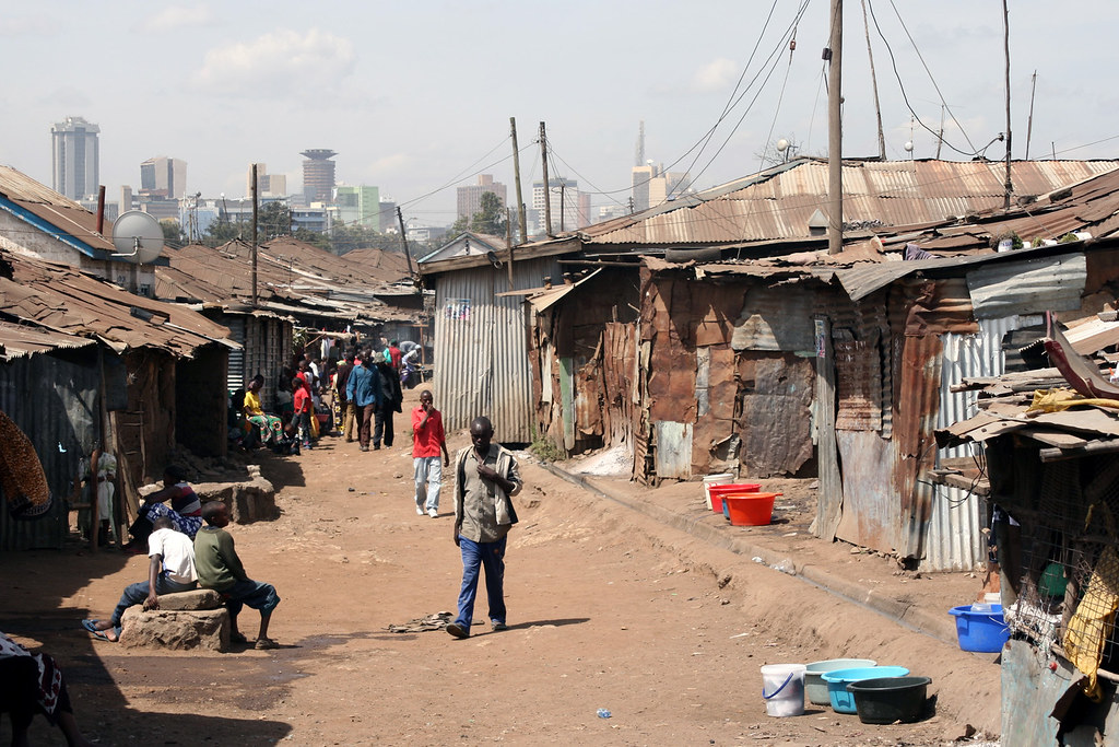
Think about it, the majority of the development we have today is happening only for a lucky few of us who have access to credit and proper basic services like energy and water. Meanwhile, the majority of the population continues to live in poverty in highly polluted and highly concentrated environments.


Do we dare imagine that we are contributing to world-wide social justice and cleaner environments when only a small percent of the world’s population reap the benefits? And of that small minority only roughly 5% are consciously taking measures to be environmentally friendly? How can we achieve the goals we set for our planet if we don’t include the majority of us – the poor – into our plans?

My straight answer is – we cannot. Period.

Regardless of how much we recycle and build green; or how much we develop and force corporations to do their clean duty; or even how much we try to produce environmentally friendly materials and programs; it is all fruitless if the majority of us humans don’t or can’t participate in the global movement.

Therefore, we must address the issues of poverty in order to tackle the problems with our environment.

To further illustrate this, I would like to give a short and quick explanation of De Soto’s theory.

It explains that unregistered properties have no proper ‘value’ attached to that land. For instance, if a person were to take an unregistered piece of land, build on it and use it, the property will still have no value because it is not officially legal. If this person decides to sell their developed land to someone else, there is no proper documentation that can connect this person to that property or transfer the property title from one name to another. Therefore, anyone or any government can simply take the land at any time because it is not properly registered and push those people outside without any legal protection for them. As a result, these properties are entered into the ‘shade’ or black market and are not accounted for in the official market.

In order to grasp the magnitude of this problem, we need to multiply this one property by a million to understand that entire neighbourhoods, communities and even villages that have residential, commercial, industrial and agricultural value currently exist only on the black market. And since these groups are not officially recognized on paper, they do not have any official value to support them in the real market.

So the first step we need to take to get these ‘shade’ properties into the market is to connect each property to its owner and then help them enter formal markets. There, they can retain official value of what they own and have the ability to engage in real business or apply for legitimate loans and credits without fear from any person, organization or law that may have intimidated them before.

Yet before we can implement such a theory, where it is needed, and for it to work properly, several supporting steps need to take place. This includes remedial action such as fixing political problems and fighting corruption, as well as providing awareness and incentives for environmental improvement and sustainability. We also need to factor in the cultural, traditional and custom layers into the property right laws to discourage any corruption among the poor. We simply want to make business easier to do in these communities instead of killing it.

Educating the poor about property rights and then teaching them to be responsible land owners and showing them how to incorporate green practices into their daily lives would be our best contribution to help slow down climate change. Meanwhile, we must also continue pushing corporations to do their share by conducting more research and finding new ways to clean up the earth- an earth that includes everybody, even the poorest of us all.


Majora Carter, one of the speakers at the Smart Growth Conference, shared with us her success story about bringing justice back to her own neighborhood of South Bronx, New York. Carter worked with her community to improve their run-down neighborhood by treating polluted areas, planting parks and building community centres that introduced education programs to help improve community wellbeing.

Yes, we must educate the poor. Yes, we must improve their corrupted systems. And yes, we have to introduce a democracy to them in the way that works for the main goal and not to our western standards. I believe that we can achieve it all by connecting theories and working with organizations that have clear visions and passionate people who work hard for their community. This is the key to slowing down environmental deterioration and it is for this reason I have chose the title to my article.

I started my post with Paul Hawken and now I will close with him saying:
‘Working for the earth is not a way to get rich, it is a way to be rich’


Image Sources: Gaining Ground, Paul Hawken, Power of the Poor, Poverty, Majora, Flowers

Cities Stand Together in the “New Normal”

by Lydia Heard, VIA's Urban Planner

On October 14th, a Mayor and Managers Summit was held in Redmond, organized by NextGen Today, in partnership with the attending communities, and hosted by Redmond Mayor John Marchione and Kirkland City Manager David Ramsay. The attendees were representatives of towns and cities ranging from 1,000 to 85,000 residents, from strong mayor to mayor-council-manager governance, from 85% residential base (Maple Valley) to twice as many jobs as residents (Redmond). Some had administrations with paid staff support; others had mayors who essentially volunteer their terms of civic service and receive a stipend for their labors. All were facing similar and urgent challenges and seemed truly hungry for the opportunity to hear from their fellow civic leaders what issues they were dealing with, and the solutions and best practices that they might share.

Focus on Funding
The morning session was titled “Navigating the Turbulent Waters” and began with attendees describing where they felt their city budgets were – above water, treading water, or underwater. Many were trying to find funding for capital projects (infrastructure). Funding was uppermost on everyone’s minds. There was much discussion about I-1033 along with the worst-case assumption (at the time) that it would pass, and that voter tax referendums are now the “New Normal.” There was dismay over the raiding of the Public Works Trust Fund this year to make up state budget shortfalls. There was stated interest in asking the legislature, once again, to change the constitution to allow for TIF (Tax Increment Financing) funding for infrastructure, affordable housing and transportation. There was much discussion of Levy Lid Lifts (involving the 2001 limit on property tax increases) to make up budget shortfalls. There was talk about local Tax Benefit Districts, and local car tab taxes (MVET).

The New Normal, it was generally agreed, was a move away from voters as “citizens” to voters as “consumers,” who are more likely to vote to tax themselves for specific local benefits rather than for a more general, widespread common good. This seems to entail a move away from general funds towards specific funding levies. Voters will be more likely to vote for tax measures for visible, tangible benefits such as Parks and Public Safety – but who wants to pay for things like “Administration” or such an esoteric good as “Planning”? Each Tax District represents a new bureaucracy with its own costs. Each election for a voter referendum generates its own costs. How are the elections that will be necessary in the New Normal to be funded? The general agreement was that the present funding structures – from property taxes, sales taxes, B&O – are not sustainable. There is a need for long-term funding structures, and that will require state legislative attention.

Smaller cities are pressed to create partnerships with each other, to consolidate services, to put services into a separate taxing district. This causes some consternation over preserving local identity – but cities are not the services they provide; they are the embodiment of a shared local vision of aspirations for the future. Partnerships, rather than special districts, may provide economies of scale while retaining a sense of local control. There are different models for consolidation. In this gathering the civic leaders expressed a desire to learn from each other what they have done in this regard, perhaps in workshops to share best practices.

Local Community Vision: Transportation and Land Use
The afternoon sessions dealt with transportation issues from the statewide scale of connecting cities, as addressed by WSDOT, to transportation and land use visions, practices and innovations at the local and regional scale. WSDOT is focused on providing connections between cities; many planned improvements to this end were left unfunded when the 2007 RTID (Regional Transportation Investment District) failed. Rural communities have a sense of inequities from the PSRC 2040 vision for growth. Smaller communities such as Maple Valley, Black Diamond and Carnation band together to buck this perceived trend and are working to put together their own commuter rail line.

Where statewide responsibilities leave off, local governments require a vision and a strategy for what they want to achieve. Nothing can be done without funding, but the danger of a focus on narrow funding channels is in loss of vision and of larger planning issues. Communities and cities have their own context for a vision of land use that then sets the context for highway and transportation improvements.

Redmond, for example, was once a single-family bedroom community that was required to become a growth center under the GMA. They invested in the infrastructure downtown, to encourage development there. They have a vision for a better housing to jobs balance and for diversity in housing choices. They also have a vision for overall connectivity and for the eventual arrival of Sound Transit, and it is part of their planning. They have prepared for dense centers around proposed stations and are ready for it to happen. Redmond also organized as one large traffic concurrency zone in order to accommodate a citywide bicycle network.

Parking Management is also an issue. Strategies such as lowering parking requirements, giving developers the option of providing transit passes instead of parking, using shared parking arrangements, and other tools that the different communities are trying were discussed. SeaTac offered a land use test case. They have two transit stations going in, along with a huge demand for airport parking, making surface parking lots more lucrative than other commercial or retail uses. They have to subsidize retail in order to promote mixed-use development around the transit stations, which are there to serve the airport rather than the community. Parking, land use and transportation overlap and require a strategy that changes over time.

The issue of Transportation Impact Fees came up. They can only be used to pay for vehicle infrastructure; how might that funding be used to pay for bicycle and pedestrian facilities? Redmond has done something very innovative in this regard. Instead of Transportation Impact Fees, they charge Mobility Impact Fees and have developed Mobility Units to measure charges and credits. For example, if a developer puts in bicycle infrastructure, they get back some mobility credits to offset mobility fees. It’s never been tried before and is something of an experiment. So far, no one has challenged it.

The challenges faced by cities in the New Normal, even condensed into the discussions of a single day, seem staggering. Questions of funding ruled the day; but vast reserves of resourcefulness and innovation were very evident. Land use and transportation, tools such as parking management, transportation concurrency, commute trip reduction, service partnerships, and entirely new innovations through merely substituting “mobility” for “transportation” provided  much to work with. The greatest benefit among civic leaders seemed to be the recognition that, in sharing the issues they face, they are also sharing potential solutions – and not bearing the burdens entirely alone.

Silence of the Squash

We submitted a pumpkin this year for the annual Carve for a Cause that benefits Architects without Borders (more info here).

Last year, we did the artichoke lamp, but were disqualified for using too much "non-pumpkin" material:


For those who don't know what I'm referring to, here's a picture of the artichoke lamp:


So, this year, we decided to step up our game. Our interior designer came up with the idea of doing a pumpkin modeled after Silence of the Lambs or making something out of pumpkin skin. After a brainstorming session, Silence of the Squash was quickly formulated. Hours and hours went into steaming the squash, scooping out the insides (you can image how quickly you can get sick of squash for every meal), and getting the skin ready to be sewn together.

Here is the pumpkin in progress:


Surprisingly, it only took us about 3 hours to sew everything together and put nails in strategic places to hold the skin in place. The next evening, we headed down to Design Within Reach to see the competition. There were some incredible entries.


After mingling at the event, they announced the winners and our pumpkin won Judge's Choice this year! After the competition, they auctioned off all of the pumpkins, which was a good way to help raise more money.


Not sure what we're going to do next year, but we're going to have to come up with something really good to top this year's entry!

Sky High or Down Underground?

y Christine Szeto, VIA Architecture's Vancouver Office

Part 1: Growing Up Riding the Sky
On a Saturday afternoon in the spring of 1992, I rode the SkyTrain for the very first time. My family usually spent Saturdays in Chinatown but we lived in Surrey. My parents were working late that day and my two older sisters thought that they could ride the train home to work on their “homework”. Of course, much to the dismay of my parents, as well as my sisters, I insisted on tagging along. Our ride would take us from Main Street Station to Scott Road. (King George would have been the closer station but it hadn’t been built yet.) I had just turned 10, and my sisters were 12 and 16.

Like all parents who are learning to trust their children, my parents were a bit worried about dropping off three girls near skid row and then having them ride the train all alone for an hour. Anything could happen -- we could get lost, or could lose a sister, especially the little sister. We could have missed our stop at Scott Road Station, or we could get off too early. Cell phones were still sort of new and expensive so there wasn’t a way of contacting us until we reached our destination. Besides, we could have lost the precious gigantic brick of a phone. “But, c’mon, get real – mom, dad, are you serious?” We only had one train line to ride, how could we possibly get lost? All we had to do was stay on the train until the end; until it couldn’t go any further.

I remember my sisters picking the last car to ride on so that I could look out the tiny back window as we rode home. It gave them a moment of peace because they knew that the view would keep me quiet – and they were right. Nothing was better to me than seeing the entire city from above as I traveled home. Time passed quickly because there was always something interesting to look at.

After several more rides, I got so used to the landscape that I began to look for specific objects or structures to judge how far along I was in between stations. It never became boring; not for me anyway. Even after years of riding the same line, there was always something to look at. Things looked different each time we rode the SkyTrain. Maybe because it wasn’t raining this trip, or the sun was setting or perhaps a building was torn down. Whatever it was, it was always worth a look.


From then until my mid twenties, SkyTrain was basically my only experience with rapid transit. It was what I knew and it was easy. Just one line and 40 minutes later I’m in the city or back at home. Of course, at times, the train wasn’t the most convenient because the stations can be quite far from my departure or destination points, but I’ve always enjoyed the ride.

So, because I was so used to seeing sunlight and landscapes while commuting, I was a bit closed to the idea of riding a subway system. Expo Line does go underground for some stations, but the train eventually resurfaces to an elevated railway. To ride constantly underground sounded somewhat bleak and depressing, if not slightly claustrophobic. I also wasn’t the most attentive commuter – I guess I was too busy looking out the window – so changing trains did not seem favorable either.

Just last September, my husband Stanley and I vacationed in Paris and we thought it would be a much better (and cheaper!) experience to visit the city as pedestrians. Besides, we had heard that driving in Paris was extremely aggravating. Obviously, then, the subway would be our main method of touring the city.

At first I got really ambitious and thought “why spend all that time underground when we can see the city on bicycles? It’s so Parisian!” But Stan wasn’t thrilled with that idea, especially when the forecast predicted rain. So, onto the subway we went and well, honestly, it was a lot of fun! I suppose since I was born and raised in the Greater Vancouver area, there’s a natural inclination to the city’s transit infrastructure – you just know what to expect – but I was wrong to be so biased. As beautiful as the city of Paris is, the transit infrastructure was also a real eye-opener for me.

Of course, understanding how the system works in a practical sense – point A to point B – and in French, is a slightly different story….

(tune in next week for Part 2 of Sky High or Down Underground?)


Here's a video clip of the original test track from the mid-1980's 


Images: cell phone, Vancouver skybridge, expo line map

Vancouver Streetcar: We've Missed You

by Dale Rickard,  MAIBC, Director of Transit Architecture, VIA Architecture

The streetcar is returning to Vancouver’s streets again after the original system was torn up in the 1950’s. This is a city that was organized around the streetcar starting in 1890 with a system that continued to grow as the city expanded creating a network of linked communities like Kitsilano, Marpole, Kerrisdale, Dunbar, and Mt. Pleasant. All of those communities continued to develop and mature but the streetcars that generated them have long disappeared.

I happen to live at 41st and Dunbar a few hundred feet away from a bus terminus loop. The loop was originally occupied by the streetcar turnaround built before the First World War and was built before there were any houses. The area had just been logged and there were acres of stumps where the forest had been. This is the way transit planning should be: first comes the infrastructure which then generates the development. If this is not done proactively, transit planning can become a much more challenging process of developing routes through existing neighborhoods.

The City of Vancouver is now serious about reintroducing the streetcar. Interestingly it is a City initiative proposed to be a project independent of TransLink’s larger regional system but creating connections and linkages that will make at least the inner core of the City very well served by transit choices. And like the original system of 100 years ago, it will be designed to link communities and neighbourhoods primarily in the central area: Granville Island, Southeast False Creek, Downtown Eastside, Chinatown, Gastown, Coal Harbour, and North False Creek.

This is a vision that was articulated in 1999 and approved as a concept by City Council to be developed with a series of consulting reports on ridership, costing, and preliminary engineering. The City had the foresight a few years earlier to buy a stretch of the disused CPR right of way on the south shore of False Creek from Granville Island to Main Street and, combined with this, there have been corridors planned that pass through the Southeast False Creek area, Concord Pacific, Coal Harbour, and Bayshore developments.

This vision of a streetcar system ringing False Creek and the Downtown central area will create connections to virtually the entire TransLink network including the SeaBus, the Expo Line, the Canada Line, the West Coast Express, the major buses, and ultimately even the Millennium Line when it is extended west.


Even though this vision is a few years away, the City included it as a part of the Olympic Bid Book and will be opening a short segment of this full system in January to move people from Granville Island to the Canada Line at a cost of $8.5m from the City with an additional grant from CMHC / Granville Island of $0.5m. This will fund a demonstration line running free trains intended to generate excitement during the Olympics for a couple of months, with 1.8K of single track connecting a platform at the entrance to Granville Island with another platform located behind the Canada Line station at Olympic Village. This will form part of a ring of movement around the Creek planned for the Olympics with streetcars, ferries, and bike paths connecting the seawalks, Granville Island, an Olympic venue at David Lam Park and the Olympic Village.

VIA Architecture has been a part of the planning of the system, working with HMM Engineers to do the preliminary engineering for the first major segment. This is planned to be built from Granville Island to Science World with a works yard under the Georgia Viaduct and a number of stations including the Science World station with connections to the (soon to be upgraded) Main St. Station (also a VIA project). Although a fair amount of conceptual initial thinking took place concerning the platform architecture, this has not been developed further and the 2 Demonstration Line stations will consist of a minimal asphalt platform.

The exciting thing that has been in the news this week is that the 2 cars to be used on the Demonstration Line have started their journey from Brussels, through Germany and the Panama Canal, to Tacoma and then to Vancouver. Bombardier is contributing these borrowed vehicles to showcase Canadian technology and to promote their expertise when a fleet of cars are ultimately chosen. These cars carry 50 seated and 128 standing passengers, are bi-directional, and very low-floor (300/ 350 above the tracks) which allows for full accessibility and 2 bicycles. And they look great!


The 2 stations at the entrance to Granville Island and behind the Olympic Village Canada Line Station, along with the new single track bed have been basically completed, although the station platforms will have some lighting poles and pairs of bus shelters added. The station platforms will be extremely simple and are defined by a concrete curb edge beside the tracks that create a level access into the cars.

GRANVILLE ISLAND STATION


OLYMPIC VILLAGE STATION